The First Iron Bridge |
BRIDGE HISTORY“Moses Godfrey, apprentice to Mr. Roundy, crossing the falls was carried out by the current and drowned.” – January 1, 1767 entry from the journal of Jonathan Darling, Jr. (Bangor Historical Magazine, Volumes 1-3, p. 308)
Before 1830, there was no bridge connecting the Blue Hill Neck, as it is called, or South Blue Hill, with the island or the rest of the Blue Hill community. Therefore the community had to be relatively self-sufficient in providing their own food and shelter. Farming was most likely subsistence farming with each landowner working a plot of ground to grow sufficient fruits and vegetables to take care of his family and perhaps some to sell or share with neighbors. Blue Hill citizens living on “The Neck” – the peninsula jutting north to the Reversing Falls between the Bay and the Salt Pond – were isolated from the rest of town by water until the middle of the 19th Century. To reach the center of town, citizens on The Neck were forced to journey through Sedgwick around the south end of the Salt Pond – no easy journey in the days of horsepower – or to take their chances crossing the Falls. More than one early settler died trying to cross what was then called the “Fore Falls.” Town meeting minutes indicate that the first permanent bridge to span the Falls was erected in the Fall of 1852. At a Town Meeting in March 1851, Bushrod Hinckley, Arthur Drinkwater, and Reuben G. W. Dodge were appointed to a committee to work with an engineer to identify a good site and estimate the cost of a bridge. At a Town Meeting a year later, town citizens voted to build the bridge and pay the builders $1000 within six months after the Selectmen certified that the completed span was acceptable. The Selectmen so certified in February 1853. The first bridge was a wooden structure and vulnerable to high water and ice. Town records and other accounts indicate that the first bridge was replaced and repaired more than once in the next thirty years. At Town Meetings in March and April 1883, the people of Blue Hill voted “see what should be done” about the Falls bridge and authorized the selectmen to seek estimates for an iron bridge as well as a new wooden structure. In a Town Meeting that September, the East Berlin Bridge Co. of Connecticut presented an estimate of $1800 for an iron bridge, “the town to furnish the woodwork and take away the old bridge.” Town citizens voted to build the iron bridge and authorized the selectmen to “hire money” to pay for the bridge at the rate of $300/year. The Iron Bridge across Blue Hill Falls, Built 1883 (From the Blue Hill Historical Society historical postcard collection) The iron bridge was replaced by the current concrete structure in 1926. At a Town Meeting that year, citizens voted to build both a new “Falls Bridge” and a new “Tide Mill Bridge” at the other end of Mill Island and to raise the level of Falls Bridge by three feet. The new bridge was named the “Stevens Bridge” in honor of Austin Stevens, one of Blue Hill’s leading selectmen of that era. The graceful arches of the Stevens Bridge are a historical landmark in Blue Hill. With occasional refurbishing by the State, the bridge has survived for 92 years and is scheduled for repair or replacement in 2020 or so. Through their votes at Town Meeting, town citizens have been intimately involved from the beginning in decisions about how and with what to bridge Blue Hill Falls. They may soon be asked to help decide the next step in the history of the Falls Bridge. Town leaders report that Maine DOT has added to its long-range plan a decision to either carry out a major restoration of the current structure or to replace it with a new bridge that would change the character of the landscape around the Falls. What did folks in South Blue Hill do for a living and to support their families? The area around the Neck and the Falls was the first settlement at Blue Hill and was the center of activity until around 1800, when the action moved up to the “head of the bay.” The first meeting house and the first cemetery were in this area, but their exact location is now a mystery. The first town meetings were held in the meeting house there and some of them in Joseph Wood’s house. |
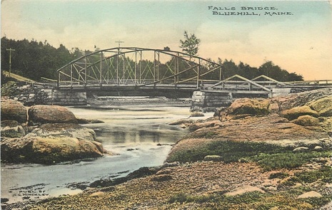
The following images show the 1st iteration of the Iron Bridge over the Blue Hill Falls. All are pre-Arcady. You can identify that this is the older Iron Bridge because when looking at the North Side of the bridge (Mill Island) there is a triangular wood support structure that is the support for the short bridge between the land granite buttress and the granite buttress fully in the stream. In the second version, the wood structure is gone and a short Iron Bridge covers the span - similar in looks to iron railroad bridges over roadways. Today that space is all granite and there are two (2) not three (3) granite buttresses.
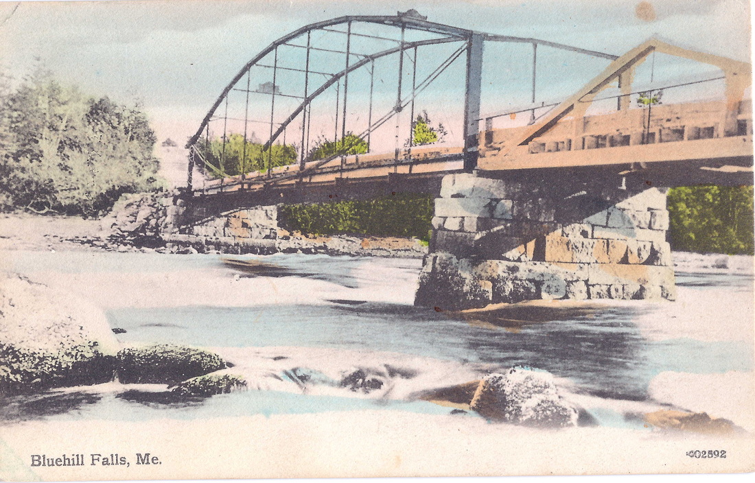
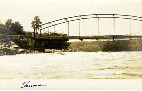
The Second Iron Bridge
The second Iron Bridge over Blue Hill Falls is differentiated by the short iron bridge leading to the larger trussed structure in the flow. Arcady can now be seen in some of the photos, as well as construction equipment for the trussed bridge. In some of the photos "telegraph" poles run on the bay side of the photos. In others - the later (circa 1913 or so), when power first came to that part of Blue Hill, those are on the Salt Pond side. Today the power, phone and cable lines run on the pond side.
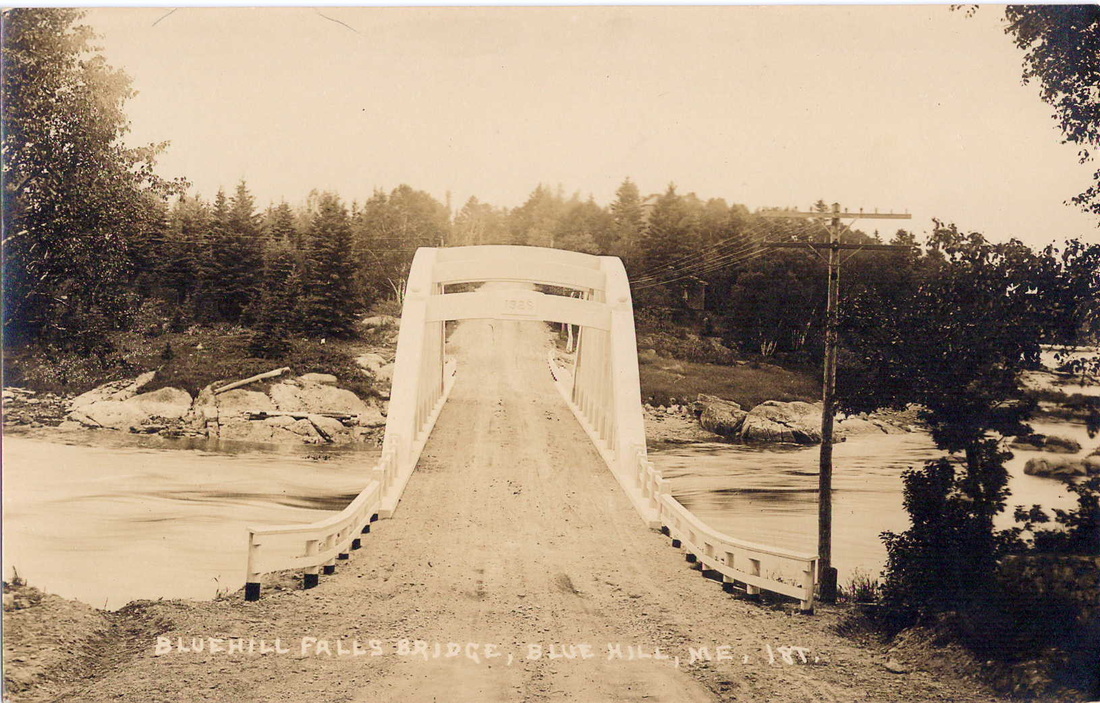
The Stephens Bridge of 1926
The following photos of the current Blue Hill Falls Bridge, more formally known as the "Stephens Bridge," are divided into two elements. The first is the construction and the second the finished structure. The photos are not in sequential order at this point, but that effort will be made when time allows. It is clear what is construction and what is not though. In two of the photos in the second element - near the end - the structure that was associated with the "chimney" that now sits on the Blue Hill Neck side of the bridge, can be seen. The structure was removed when the road was widened and the dirt road eventually asphalted over.
The Late 1970's - Kayaking and other Fun at the Falls Bridge
(Homer Heller is the guy facing the camera)
The following is a Blue Hill Historical Society Article. Some corrections have been made to typos and misspellings though it has not been fully reviewed for accuracy.
Blue Hill Historical Society
November 28, 2021
The early settlers of Blue Hill lived on what was known as “The Neck” - the peninsula jutting north to the Reversing Falls between the Bay and the Salt Pond. John Roundy’s first cabin foundations were later uncovered on the property across the street from Arcady, the Italian-like villa that was constructed for Ethelbert Nevin’s widow.
These early Blue Hill citizens were isolated for the most part, save for the rare treks through Sedgwick around the south end of the Salt Pond. It was that or face the dangers of the “Fore Falls” as they were called. Jonathan Darkling Jr. recalled such risks in the Bangor Historical Magazine in 1767, writing, “Moses Godfrey, apprentice to Mr. Roundy, crossing the falls was carried out by the current and drowned.” Godfrey wasn’t the only casualty of these tides, over the years several people including young children fell victim to the whims of the Falls.
The earliest settlers such as Roundy and Wood, seemed to live with the obstacle, fjording the falls when they were frozen or going the long way around. Jonathan Fisher, the town’s first parson, suggested that settlers should build a bridge to connect the sections of the town; he even did some surveying work towards that end. However, the cost of such a venture was daunting for a young community and the idea was scrapped.
As the population grew, so did the desire to connect it’s fragments. However, some locals were opposed to the building of the bridge, believing that it would block the Tide Mill’s flow and navigation. In 1834, Bushrod Hinckley wrote: “I find great opposition to the Bridge across the Falls from M. Allen Clapp...It will probably be lost unless we have a draw. The objection is that the navigation of the mill will be obstructed-- one would suppose the Salt Pond was a place of great business, one next to the Kennebec River in commercial importance.”
Bushrod Hinckley seems to really press the issue, as by 1851, the Town Meeting minutes indicate a vote for a permanent bridge to be erected in 1852. Bushrod Hinckley, Arthur Drinkwater, and Reuben G.W. Dodge were appointed to work on sourcing an engineer for the project and outlining its costs. Ultimately, the first bridge was a wooden structure that cost the town $1000 to be constructed. However, the high waters, the tides and the ice buildup all lead to innumerable repairs done on the bridge over a 30-year period.
In 1883, pressure to replace the feeble wooden bridge led to talk of making an iron bridge. The selectmen sought out an estimate, eventually finding the East Berlin Bridge Co. of Connecticut who presented an estimate of $1,800 for the project as long as the town would “furnish the woodwork and take away the old bridge”. The bridge was completed, giving the crossing a similar look to railroad bridges, and for a time seemed to suit the needs of the public. During this time, the town began to see much more traffic flow between the various parts of Blue Hill as the Mining Industry brought folks from all over. The roads of unpacked dirt that ran over the bridge, unpaved at the time, were constantly being wetted down by the water sprinkler wagon from the Village Improvement Society to cut down on the dust - further improving the experience of trans-town travel.
With the advancement of the automobile and the increased traffic, the iron bridge began to waver under the pressure of its use. In 1926, the Iron Bridge was replaced by the current Blue Hill Falls Bridge, known by some at the time as “Stevens Bridge” - as of 2021, it is one of two remaining rainbow arch bridges designs remaining in Maine. The bridge was dubbed the “Stevens Bridge” in honor of Austin Stevens, one of Blue Hill’s leading selectmen of that era.
For almost a hundred years, the bridge carried Route 175 traffic between Salt Pond and Blue Hill Harbor, connecting South Blue Hill to the rest of the Peninsula while also providing a popular location for canoeists and kayakers. In 2016, discussions had begun to circulate between the town and the Maine Department of Transportation to either rehabilitate the deteriorating Falls Bridge or replace it entirely. The Maine Historic Preservation Commission under Senior Archaeologist Arthur Spiess were called in to look on the site of Roundy’s cabin, finding several Revolutionary War-era artifacts and 2,000-year-old Native American pottery. A similar archaeological dig had been conducted in the 1930’s, which had uncovered the graves of 22 indigenous individuals. These remains were reinterred in 1990 by members of the Maliseet and Passamaquoddy tribes. By 2019, the Maine Department of Transportation announced it was going to undergo a three-year plan to replace the 1926 bridge in favor of a wider, more modern bridge. Until that day comes, travelers can still continue to enjoy the historic bridge as a popular tourist destination for kayakers and appreciate the “home-grown” granite foundations of its arched form. See the video below from The Maine Spotlight for some really interesting drone footage: https://www.youtube.com/watch?app=desktop&v=5mtY2iCEcpM...
#localhistory #storytellersunday #fallsbridge #ThenandNow