|
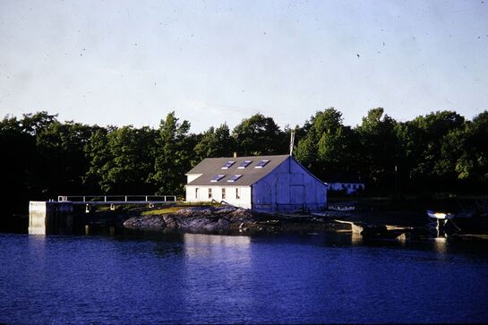
The RED boathouse on Conary Cove in Blue Hill Falls was built in the 1920's by the Haskell family who summered in Blue Hill. It was for the storage and repair of their boats and was not a commercial enterprise or working boatyard. As you may note from a photograph on the site, it was originally a white color, repainted RED in the early 50's by the LeVeque family.
|
|
Something to Read
Want to know more about Blue Hill and areas of the Blue Hill Neck (South Blue Hill) and the Tide Mill District (Blue Hill Falls)?
The attached book - Historical Sketches of Bluehill, Maine by R. G. F. Candage, was printed for the Bluehill Historical Society in 1905. It is a great detailed read and may shed light on a few things you might not know. Of particular interest may be the areas known as "The Neck" and Tide Mill District (or Neighborhood) which is specifically referenced on pages 3 thru 30 (1st para.). A quote from Page 14, "The Tide Mill neighborhood began at the Coggin lot (on Salt Pond Rd.) and extended to Bragdon's Brook and just beyond, where the schoolhouse stood in which the writer first learned to lisp his "A B C's." Some discussion on a bridge to the Neck occurred before 1842 and can be found on page 11.
Additionally, one of the first settlers whose name was referenced as the location for what is today East Blue Hill, is noted on page 3, the 1st written page of the book. His name, Mr. James McHard (this spelling is correct). "McHards" became the village of East Blue Hill in 1871, but had always been a part of Blue Hill though almost impossible to get to as there was no road to that part of the town. The first road built after 1871 went down what is now the York Rd. and then straight down the hill to the Jay Carter Rd. Only a house and then utility poles exist there now. The current RT 176, from Woods Pt. to the village at the bridge, was a modification of that road and was completed sometime in the early 1900s. How things change.... The name is also correctly referenced in the 2nd book attached below, as an added benefit in getting this far. Please see (and enjoy) the second file attached below.
It is the book - "Head of the Bay" by Annie Clough, published in 1953 but with this correction on page 41.
Number 18: Manor House in Blue Hill Falls, was bought by Mrs. Samuel Ashhurst (corrected spelling) in 1926 from Mary B . McCreight, with an adjacent property purchased in 1927 from Chandler M. Wilson. Both were combined into one property.
|
|
|
The Photo Project
Various slideshows are being developed for specific areas of Blue Hill Falls and the Blue Hill Neck (South Blue Hill). They are generally photos from 1800's to the the 1930's, but some are also included that may depict changes significant enough to be included - one is the Boathouse above, that in the early 1950's was actually white (or a light gray) - not red. Another project will take several significant "old" photos and take a new one - from the same perspective/location - to depict the significant changes over time.
Some slideshows will be on their respective pages (Bridge, Fishing, etc.) and others may appear here as they are developed.
In constructing these slideshows, new images may be added if significant - over time.
Please come back and you may see new ones as that happens.
If you have old photos that might fit this project - that we might not have already, please let me know.
We will try to categorize all that we have in early 2019.
Note:
1. We are not converting negatives or slides.... digital files or paper photos work best at this point. In both cases you retain the "originals."
2. I am more than happy to come by and check to see what you have! Just click on my name and send me an email.... Butler Smythe
The Tide Mill District (Blue Hill Falls)
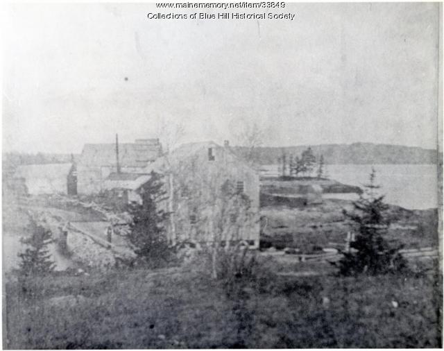
The images below are perhaps the oldest we have available and are interesting and informative. In the left photo, the photographer stood at a the high point of Mill Island above the “Tide Mill House,” looking north towards Conary Cove. In the right photo is a man standing by the mill. It was NOT a road then and there was no bridge to the Blue Hill Neck.
1) The white building(s) in the center are “Manor House” and its barn that stands between the Mill Pond on the left and Conary Cove.
2) To the right side of the image is a large two story structure that burned in the mid 1800’s - the Tide Mill. It sat to the right of the dam, which served to generate the hydrodynamic flow that enabled the mill to operate its equipment - long before electricity was available. If you walk or drive on the Mill Pond Dam, the Mill would have been on the bay side of the roadway.
3) Just beyond the Mill are three buildings - two on the right side of the road and one on the left. The first on the right side is a structure that belonged to Benjamin Clay and was built in 1833. It was torn down in the 1930's. The other, just beyond that, was a larger building that served as a store - Dana's (for part of its life). Both sat on the piece of land immediately after the Dam on the Cove. To the left is a smaller building that sat on the rocks to the left of the Dam and served as a boat building related structure on the Mill Pond and was owned by the Conary family. The land on the right was recently provided to the Town of Blue Hill for water access (The Nub).
4) Immediately above the smaller building is the Federal Style home at the head of Conary Cove, one of the earliest photos of that structure, which was built about 1830.
5) Note that the Red Boathouse on the cove is not there! That building did not exist until the early 1920's - for personal boat repair/storage.
Note: Many other photos of this general area follow - taken during later time periods that include structures which did not exist at the time this photo was taken; some that include the same buildings. The challenge is to place yourself where they were taken and observe how things have changed - or not.
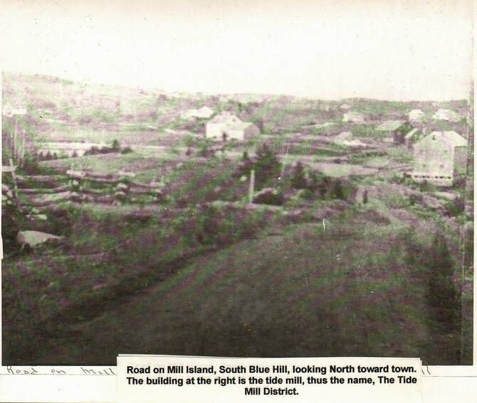
The reference to "South Blue Hill" in the photo to the left below is actually Blue Hill Falls. South Blue Hill is on the Blue Hill Neck.
1) The white building(s) in the center are “Manor House” and its barn that stands between the Mill Pond on the left and Conary Cove.
2) To the right side of the image is a large two story structure that burned in the mid 1800’s - the Tide Mill. It sat to the right of the dam, which served to generate the hydrodynamic flow that enabled the mill to operate its equipment - long before electricity was available. If you walk or drive on the Mill Pond Dam, the Mill would have been on the bay side of the roadway.
3) Just beyond the Mill are three buildings - two on the right side of the road and one on the left. The first on the right side is a structure that belonged to Benjamin Clay and was built in 1833. It was torn down in the 1930's. The other, just beyond that, was a larger building that served as a store - Dana's (for part of its life). Both sat on the piece of land immediately after the Dam on the Cove. To the left is a smaller building that sat on the rocks to the left of the Dam and served as a boat building related structure on the Mill Pond and was owned by the Conary family. The land on the right was recently provided to the Town of Blue Hill for water access (The Nub).
4) Immediately above the smaller building is the Federal Style home at the head of Conary Cove, one of the earliest photos of that structure, which was built about 1830.
5) Note that the Red Boathouse on the cove is not there! That building did not exist until the early 1920's - for personal boat repair/storage.
Note: Many other photos of this general area follow - taken during later time periods that include structures which did not exist at the time this photo was taken; some that include the same buildings. The challenge is to place yourself where they were taken and observe how things have changed - or not.
The reference to "South Blue Hill" in the photo to the left below is actually Blue Hill Falls. South Blue Hill is on the Blue Hill Neck.
|
|
Blue Hill Falls - Tide Mill District
Conary Cove & The Mill Pond Photos
The Blue Hill Falls Post Office was established on 1 May 1852
Roundy & Wood Tablet Dedication Day - 1910 |
|
Joseph Wood and John Roundy Settled on Mill Island in 1762 in that was to eventually be called Blue Hill. For a time it was known as "Head of the Bay."
A tablet now sits on mill Island close on the pond side of the road near the Mill Pond Dam. In the photos that follow, Blue Hill citizens gather in 1910 on Mill Island in Blue Hill Falls for the unveiling of a monument celebrating the founding of the town. Wood and Roundy sailed up from the Boston colony to start a new town; the first settlement in Blue Hill was in the area of Mill Island and was referred to as the "Tide Mill" district, derived from the fact that two mills were built near this site that were powered by the tides. Wood and Roundy were at the beginning of a land rush to settle the downeast Maine coast that came after the end of the French and Indian wars clarified Britain's sovereignty over the this part of the coast. This postcard is postmarked 1911.
A tablet now sits on mill Island close on the pond side of the road near the Mill Pond Dam. In the photos that follow, Blue Hill citizens gather in 1910 on Mill Island in Blue Hill Falls for the unveiling of a monument celebrating the founding of the town. Wood and Roundy sailed up from the Boston colony to start a new town; the first settlement in Blue Hill was in the area of Mill Island and was referred to as the "Tide Mill" district, derived from the fact that two mills were built near this site that were powered by the tides. Wood and Roundy were at the beginning of a land rush to settle the downeast Maine coast that came after the end of the French and Indian wars clarified Britain's sovereignty over the this part of the coast. This postcard is postmarked 1911.